


search the Original Green Blog

once a New Orleans neighborhood, now the dark underbelly of a Cheapway
The Cheapway is "the thoroughfare formerly known as the Freeway." The Freeway, of course, was originally designed to run freely in the countryside, carrying people quickly between cities and towns. But when it entered the city, the Freeway metastasized into its evil twin: the Cheapway.

nothing much grows next to a Cheapway except
warehouses, seedy bars, strip joints, and weeds
It is so named because it has likely destroyed over a trillion of dollars of real estate value around it in the US and drains municipal coffers across the country of billions in property taxes and sales tax revenues. As a matter of fact, most Cheapways destroy substantially more real estate value than the several-million-per-mile that it costs to construct them.
Cheapways were originally built to allow people to move to sprawling suburbs but work in the city. City-dwellers don't need them to get to their jobs downtown, of course, because they're living there already. So make no mistake: Cheapways weren't built for the city, but for the sprawling suburbs.
That might have seemed like a good idea in the late 1950s, but in less than a decade the Cheapway Consequence was becoming pretty obvious: pretty much everywhere they went in the city, decline and crime followed. This is so embedded in our culture that the underbelly of the Cheapway is second only to the parking deck as a setting for scary movie scenes.
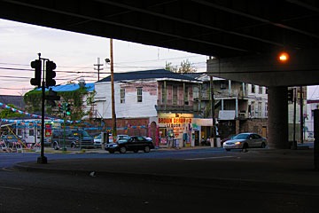
under the Cheapway
It is no coincidence that the arrival of the Cheapways heralded urban flight. Most American cities had emptied of the residents who could afford to leave by 1980. And then a really sad thing happened: Because they were then so scary, central cities no longer were perceived as good places to work. "Urban core" sounded almost as terrifying as "reactor core" for a generation to Americans. And so the jobs moved out to the suburbs, following their workers.
Now, we really must ask: if the suburban jobs are held mostly by suburban sprawl-dwellers, why do we need the Cheapways anymore? Haven't the cities suffered enough? Isn't it time to tear them down? John Norquist has been asking that question for years as champion of the Cheapway tear-down, beginning in Milwaukee when he was mayor there. He has now gone national with this cause as one of his roles as president of the Congress for the New Urbanism.

Cheapway crossing
It is far beyond the scope of this blog to show precisely how much value is lost; that sorely-needed study would best be handled by a university and could take years. But we can do a quick "smell test" that at least gives us a hint of the enormity of the problem. I chose Indianapolis for the test area because it's the city with Cheapways closest to Muncie, which was the site of the famous Middletown: A Study in Modern American Culture by Robert and Helen Lynd in 1929. I hope that Indianapolis is therefore pretty close to a US average condition.
After much searching, I found the wonderful City-data.com site, which has all sorts of great information you can drill down into. It's kind of like "GIS with a human face," meaning that you don't have to go to school to run it.
Particularly useful was their property tax assessments pages. They don't have every city, but they do have Indianapolis… or at least some streets in Indianapolis. East New York Street runs from the city center across I-65/70 and beyond.

the sample area, and properties sampled below
The following are some of the property values along East New York Street. I've shown them in red above; 302 is the leftmost property and 1417 is the rightmost property. Values are rounded to the nearest thousand dollars because my calculations are based on my measurements of the apparent site size from Google Earth, so I'm liable to be off by more than a thousand dollars because of not knowing the precise site size.
302: $2,646,000/.975 acres = $2,713,000/acre
359: $114,300/.034 acres = $3,319,000/acre
404: $50,100/.103 acres = $485,000/acre
434: $27,600/.063 acres = $437,000/acre
512: $66,900/.092 acres = $724,000/acre
602: $28,600/.241 acres = $119,000/acre
620: $30,000/.121 acres = $249,000/acre
719: $15,200/.201 acres = $76,000/acre
Interstate 65/70 occurs here, so for a distance of almost 400 feet, there is no real estate value because all of that land is in the right-of-way.
929: $35,500/.955 acres = $37,000/acre
1210: $7,500/.112 acres = $67,000/acre
1417: $10,400/.133 acres = $78,000/acre
Random samplings further eastward stabilize for quite some distance at $75,000 to $80,000 per acre. So how do we make sense of all this? Obviously, the land values drop precipitously beginning a few blocks from the interstate, then rise again to the level of the neighborhood on the other side. But had the interstate not been there, the value would likely have feathered more gently to the eastern neighborhood. The red curve below is the existing value The difference between the two curves below (the green area) is the value lost.

the sample area, with values above
I've assumed that the eastern neighborhood is held to its base value up to the outside of the Cheapway right-of-way. In reality, the downtown might extend value further. The total width of area affected is 4,728 feet - a swath nearly a mile wide along the Cheapway. The average property value lost over the affected area is $173,000 per acre. So in one mile of Cheapway, the total area is 4,728 feet x 5,280 feet = 573 acres. At $173,000 per acre, the Cheapway kills a staggering $99 million of real estate value per mile!

John Norquist told me that according to the 2004 Status of the Nation's Highways, Bridges, and Transit: Conditions and Performance report produced by the FHWA for Congress, there were approximately 46,747 route miles in the US Interstate System (circa 2002). About 70.8 percent (33,107 route miles) were in rural areas, 3.9 percent (1,808 route miles) were in small urban areas, and 25.3 percent (11,832 miles) were in urbanized areas. These figures are ten years old now, so the real number would now be larger, but if Indianapolis is average, then 11,832 miles losing $99 million of real estate value per mile totals $1.17 trillion!
Let that sink in for a minute... then consider that the US Department of Defense reportedly had direct expenses of $757.8 billion for the war in Iraq… less than 3/4 of the Cheapway Consequence. The entire 46,747-mile US Interstate system is estimated to have cost $425 billion in 2006 dollars, making it the largest public works project in human history, but those 11,832 urban miles alone have destroyed nearly three times that amount of real estate value!
And to think that a loss so massive has been hiding right under our noses in every American city served by a Cheapway! And Interstates make up only part of the total mileage of Cheapways, since there are many uncounted miles of urban expressways that aren't on the Interstate system.
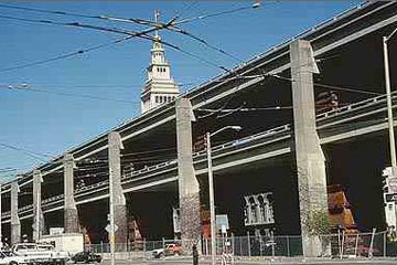
before: San Francisco's hideous Embarcadero
Expressway before the World Series Earthquake
took it down in 1989 source: geoimages.berkeley.edu
That is not, however, the end of the bleeding. According to the New York Times, the average state property tax rate in the US is 1.38%. So $1.17 trillion in lost property value costs the states over $16 billion per year in lost property tax. This number, so far as I can determine, does not include state school taxes. Many counties and cities levy property taxes as well. And a quick tour of the streets around most Cheapways reveals enough boarded-up windows that it's clear that billions in sales tax revenues are being lost as well. There is no clear way to estimate these losses because so many taxing authorities are involved, but based on the $16 billion lost just on state property taxes, the total is obviously well into the dozens of billions per year.

after: the fabulous Embarcadero boulevard that
replaced it has created untold millions of dollars in
property value and tax revenue
I normally try to draw a persuasive conclusion about the contents of a post, but the numbers above speak so loudly for themselves that there's not much else to say. Let's just say that the Cheapway Consequence is simply a burden too great to bear. The time has come to tear the Cheapways down and replace them with great urban boulevards that create value instead.
~Steve Mouzon
Note: This post is part of an extended BlogOff on Return on Investment (RoI) of municipal spending. These are the posts in the BlogOff so far… please join us!
2/20/12 - The Speed Burden, Steve Mouzon
1/27/12 - On the Street: The DNA of place and the ROI of movement, Hazel Borys
Another Note: This is part of an occasional series on the costs of sprawl I started in March 2011 with Costs of Sprawl - Part 1, and continued with The Speed Burden noted above. Lots more to come… hopefully more quickly next time.
Legacy Comments
Patrick Kennedy · Owner at Space Between Design Studio
This is good stuff Steve. We're polishing up some economic impact numbers for a "hypothetical" freeway section removal in downtown Dallas. Of a 245-acre study area, virtually all of which is ROW, vacant, or surface parking, the city collects $3.5 million in tax revenue. We're running various scenarios of eventual land value and average FAR across the site from conservative to aggressive (based on nearby and real comparables). Our most aggressive scenario isnt even that aggressive. It merely supposes uptown Dallas level values & FARs. If development post-teardown achieves 95% buildout in year 15 at the aggressive scenario, the City of Dallas would get over $100 million per year in tax revenue and well over $6 billion in total investment. Neither of these figures sound nearly as crazy when citing the 300% increase in land value along the Embarcadero.
Steve Mouzon · Board Member at Sky Institute for the Future
Following up on the Speed Burden post (http://www.originalgreen.org/.../costs-of-sprawl---the...)... another in the Costs of Sprawl series. This one looks specifically at expressways in the city, slicing them the other way, showing how they've blown a trillion dollars. See what you think.
Virginia Fitzpatrick · Bon vivant at Retired
In the early 60's my parents and neighbors fought a proposed freeway that would parallel by a few miles another North -South freeway in the San Francisco Peninsula. We lost. We sold our home and move to Japan where we did not own a car and took the train into Tokyo.
Patrick Kennedy · Owner at Space Between Design Studio
Steve,
As of yet, I've only blogged/tweeted hints along with various bulletpoints that are in our proposal. I don't too much of it getting out in the open for minds to get made up well ahead of time and shooting it down as fanciful. It's a serious proposal with serious economic impact analysis. We're polishing up our numbers before finalizing the white paper and associated ppt presentation. All of the graphics and sources have been assembled, but occasionally a new gift lands in your lap such as the latest ITDP report on case studies which is where the 300% land value increase came from:
Hold on... Having difficulty copy/pasting w/o blue tooth keyboard
Joseph Patrick Medley · Technical Writer at Google
Good work. The numbers won't be enough to change things. When I try to explain stuff like this to people who don't follow urbanism they look at me like I'm part of the tinfoil hat brigade.
Steve Mouzon · Board Member at Sky Institute for the Future
Just posted the next Return on Investment post: http://www.originalgreen.org/.../the-ecological-dividend... Have a look and let's talk!
Steve Arnold · Commissioner at Capital Area Regional Planning Comission
Great post, Steve! It contrasts starkly with MPO plans to "improve" the Madison, WI Beltline. Any thoughts on "urban freeway" effects when the situation results from building an interchange and an NU new community along a formerly rural freeway?
Rob Steuteville · Editor/Publisher at Public Square: A CNU Journal
Steve, that's an interesting analysis, yet I see one problem with the numbers. You are not measuring a mile along the highway, you are measuring a point along the highway — since the mile is a transect of a street perpendicular to the highway. This would actually tend to underestimate the property tax value impact.
Rob Steuteville · Editor/Publisher at Public Square: A CNU Journal
Okay, now I see that the calculation involves an area that would occupy a mile on the highway. My mistake.
charlesnathansiegel
It is interesting that there are two types of comments here. Most agree with Steve's original premise about "economic impact": more money is better. But Steve also agrees with the comments that say it is better to live in cities where you spend less money.
If you really calculated the entire economic impact of urban freeways - not just the impact on real estate values but the impact on the entire economy - there is no doubt that you would find it increased the Gross Domestic Product. Cars cost money, gasoline costs money, and all that cost is added onto the Gross Domestic Product and, in the conventional accounting, the increase in the GDP is considered as a good thing.
Yet cities where you don't have to drive are actually more livable, even though they add less to the GDP than cities where you do have to drive.
Many economists are now working on alternative measurements of well being. With a more sensible measurement, it would not matter if freeways added more in real estate value in sprawl suburbs than they subtract in real estate value in cities.
We should be looking at what sort of urban design generates the most monetary spending, since that spending could be counted as a cost as well as as a benefit.
Instead, we should be looking at what sort of urban design generates the best quality of life at the least cost - and walkable neighborhoods obviously do far better than sprawl suburbs.
John Williams · Editor of CenterLines, e-newsletter, since 2000 at National Center for Bicycling & Walking
Don't forget what freewayization did to Overtown in Florida... http://bit.ly/zGhXoM
Nicolas Derome · Waterloo, Ontario
Although you might be right that freeways reduce the values of land immediately adjacent to them, using just a couple data points for your whole argument is inadequate because there can be a lot of variation in real estate values in a given location, especially if the property is developed to different levels.
I looked at zillow and the home among their "recently sold" listings that is closest to the freeway (on the block adjacent to it) sold for $410k and is on 1/10th of an acre. In other words... a higher property value ($4.06m/acre than all the other properties you looked at.
Looking at assessed values for vacant residential lots, the values do seem to decline as you approach the freeway from the west, but they continue to drop going further east, even well past the freeway, as arguably the most ghetto* part of Indianapolis is about 1-2 miles east of the freeway.
*Ghetto as in poor with lots of vacant housing, this is a rare example where such a neighbourhood is relatively mixed ethnically.
2,200+
