


The Ecological Dividend
search the Original Green Blog

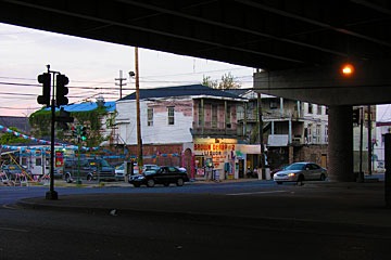
Schooner Bay house looking out to sea across preserved coastal landscape
Many New Urbanist places have for years sat more lightly on the land than most conventional developments. Several xeriscaping principles date all the way back to the beginning of Seaside, which was designed by DPZ and launched the entire New Urbanism movement. But Robert Davis, Town Founder of Seaside, didn’t mandate native species primarily for high-minded ideals, but rather to save the cost of an irrigation system.
This tradition has continued to this day in the work of many New Urbanists. For example, the Waters was re-planned after having originally been designed by others in a sprawling pattern. The original plan called for bulldozing a hill at the south end of what we redesigned as the Lucas Point hamlet. I told the Town Founder “let me save you the money of moving all that dirt; we’ll leave the hill, put a chapel on top, and line a street up with it to let the chapel terminate the vista.” Today, Chapel Hill is the most memorable view at the Waters, but the rationale for doing it that way was purely economic.

Schooner Bay, a new DPZ-designed town rising now on the eastern shore of Abaco in the Bahamas, probably illustrates Original Green principles more clearly and broadly than any other place built in our time. The Original Green is the sustainability that existed before the Thermostat Age, which also happens to be the era during which we developed really big bulldozers, dump trucks, and the like, allowing crushing environmental impacts that simply weren’t feasible before.
Orjan Lindroth, Town Founder of Schooner Bay, isn’t simply doing the right thing. Instead, he has also analyzed the cost savings of many of these low-impact measures. He calls it the Ecological Dividend. Conventional development is driven by two things: asset inflation and bank liquidity. Because of this, these developments are primarily marketing exercises, designed to create as much sales velocity as possible. The components of the Ecological Dividend don’t show up anywhere on a standard project pro-forma, but they can be immense, as we’ll see. Let’s examine the astounding Ecological Dividend that is accruing at Schooner Bay, keeping in mind that the same can be done elsewhere as well; it’s not specific to Schooner Bay.
Time

father & son at Schooner Springfest 2011
Many components of the Ecological Dividend would not be possible in a high-velocity development bent on building out in 2-3 years. High-speed development is almost always high-debt development as well. Development driven foremost by the ticking interest clock forces decisions not in the best interest of the place. Orjan has chosen not to burden Schooner Bay with debt that requires a schedule dictated by cash flow. The market, rather than the debt, determines the pace of development. This is the way that most of the Most-Loved Places were built.
Ultimately this is far more beneficial to both developer and the community. Homebuyers are not paying significant bank finance and interest costs in their land prices. These items can amount to 30% of the cost of a new development and these benefits are passed on directly to homeowners.
Diversity

flying kites at the festival
Schooner Bay has, from the beginning, opened its doors to a diverse population of primarily Bahamians as well as foreigners across wide socio-economic strata. Because of this, it will not be subject to the generational risk faced by all single-purpose developments such as gated golf course subdivisions. Instead, the broad demographics of Schooner Bay will more closely mirror those of the Most-Loved Places of the Bahamas such as Harbour Island, Hope Town, and Man-of-War Cay. Building in this way should allow Schooner Bay to join that list of Most-Loved Places someday.
Landscaping
One clear beneficiary of this expanded timespan is the cost of landscaping. Schooner Bay runs an onsite nursery which provides all plant material for the town. Orjan plants heavily to create a subtropical paradise, but because the 200,000 trees he expects to plant will all be grown from seedlings in the nursery over several years rather than bought at a mature size from elsewhere, the savings should be approximately $38.8 million ($6/tree to propagate and grow vs. $200/tree to buy large.)
Earthwork

From the very beginning of Schooner Bay’s design, earthwork was always conceived as having multiple purposes. Every bucket of dirt that needed to be moved was slated to be used where it could create an asset. Not one load of dirt or sand has ever or will ever leave or enter Schooner Bay from elsewhere. Grading in a balanced way doesn’t just save on dump charges or borrow fees; it also saves large quantities of fuel necessary to haul the material back and forth. But the beginning of earthwork savings occurs when you decide to leave a lot of the material where it is already, like we did with Chapel Hill at the Waters. Conventional developments often mass-grade the site at the beginning for stormwater convenience and ease of construction. This also destroys all trees and other vegetation, eliminating all wildlife habitat as well. Savings on earthwork alone at Schooner Bay (existing plant material is counted below) should be about $24.4 million over conventional practices.
Forest

within the coppice
38 acres of forest are being preserved at Schooner Bay. A narrow band through the center of the forest is a parrot migration route preserved in DPZ’s original plan. But once sitework surveying began and Orjan saw the beauty of the coppice, he asked DPZ to dramatically expand the preserved area. Galina Tachieva, DPZ's Project Director and author of the Sprawl Repair Manual, marveled that a Town Founder would preserve so much green space because typical developers want to cram every available sliver of land with as many lots as they can sell. Planting a coppice like this one would cost at least $1 million/acre; preserving the whole thing cost only $200,000, for a net Ecological Dividend of $37.8 million.
Dune

front dune at Schooner Bay
Years ago, when Seaside went through its first major hurricane, it came out virtually unscathed, while there was major devastation for miles on either side. Hurricane experts from all over flocked to Seaside, and for several months afterwards, news reports referred to it as the Seaside Miracle. Analysis eventually showed that while Seaside’s higher structural standards helped, the biggest single factor was the decision to build behind the dune instead of on the dune. Orjan took this to heart, planting the first dune with thousands of native dune plants so their collective root systems will reinforce it. He then built a second dune a few dozen yards behind it, further strengthening the shoreline and providing a platform for houses just behind the second dune. The second dune turned lower-value lots with no view into oceanfront lots by elevating them, and was built using the sand spoil from the harbour excavation. It turns out that because the dune adjoins the harbour, the second dune’s location was actually the closest place the sand spoil could have been used, reducing hauling to a minimum. Building a dune in conventional fashion by hauling sand onto the site would have cost about $7.5 million, but using harbour spoils costs only $200,000, for a dividend of $7.3 million.
Interestingly, the eye of Hurricane Irene crossed over Schooner Bay at her strongest point in the fall of 2011, with winds of 125-130 miles per hour. Yet in spite of the fact that most building components (even the windows) are built on-site, not a single pane of glass was broken! Here's the full story of the Schooner Bay Miracle.
Harbour

rugged rock shoreline protects the back side of the whale-tail
of the harbour
The Harbour at Schooner Bay was the source of many feet of topsoil that had eroded over the centuries from the higher rocky land to the hollow that became the harbour. Returning the topsoil to the higher land made it more valuable, especially because Schooner Bay is doing so many things to become a Nourishable Place. Building that much topsoil for gardens would take each homeowner several years of work. The harbour itself contributes food as well, as it will be home to a small fishing fleet, making Schooner Bay an authentic fishing village. It should be noted that the natural whale-tail shape of the shoreline at this point shelters the harbour to an unusual degree, making Schooner Bay the best site for a harbour for many miles around. The dividend created by all the benefits of the harbour is estimated at $20 million.
Community Cistern

festival marching band
Normally, water is stored in steel tanks with pressure equipment, all of which is subject to corrosion and normal wear and tear. Orjan took an alternative route, building a 2-acre sand tank on the ridge 60 feet above the town center and allowing the water to gravity-flow to its destinations. Net savings are $2 million, plus all the avoided maintenance in the future. Also, material excavated to create the cistern was used to make building pads. As elsewhere, everything on the site has at least a double use, in good Cradle-to-Cradle fashion.
Eco Machine

Sewer treatment in a remote location is usually expensive, as you have to create your own sewer treatment plant. Normally, these are large, smelly, undesirable things as well. The Eco Machine lets nature do the job instead, digesting sewage below ground level in what appears to be nothing more than a long swale or rain garden planted with a variety of plants designed for each step of the digestion process. The Eco Machine trades odor for beauty, and saves $2.5 million.
Smaller & Smarter Homes

Schooner Bay champions the idea of building smaller and smarter as well as any place being built today. They are literally satisfying the same customers in half the space they might otherwise have built. So while other oceanfront developments in the Bahamas might average $800,000 in construction cost per house, Schooner Bay is doing enough clever things that they are averaging only $400,000 per house... and those houses are extremely well-built. At 500 homes, that’s a staggering $200,000,000 difference in construction cost.
But as stunning as this is, it’s only half the story. The other half is the fact that Schooner Bay will have a completely unheard-of range of 40 to 1 from most expensive to least expensive homes... or from around $4 million to just under $100,000. In short, it will feel like other great Bahamian towns like Dunmore Town, full of a complete range of Bahamian culture, rather than terminally boring subdivisions where everyone is wealthy. And yes, at this price range, most of the residents will be Bahamians instead of foreigners.
Living Traditions

model pavilion was built to illustrate construction patterns people
have not considered building in a long time in the Bahamas, but
which are eminently suited to the region
Orjan and a group of fellow Bahamians commissioned A Living Tradition [Architecture of the Bahamas] several years ago; the book has since won a CNU Charter Award. The title isn’t marketing fluff; rather, it makes note of the core aspiration of the book: to start a new living tradition of Bahamian architecture based on patterns that make the most sense for regional conditions, climate, and culture. I have tested many ideas over the years meant to contribute to restarting living traditions, and what I have found is that without a living tradition, builders will price standard suburban sprawl details as “standard price,” whereas better details that make more sense and even use less labor and materials get “custom pricing.” But once a tradition begins to spring to life in the builder community, the equation inverts: when they now know why they’re doing the better details, those better details get “standard pricing” and the bad details they don’t want to do anymore get “custom pricing.” It’s not yet clear what the savings will be from the traditions beginning to live at Schooner Bay, but it will doubtlessly be somewhere in the tens of millions of dollars.
Capital Cost Dividend
Just in case you’re not keeping track, the total Ecological Dividend of building the Original Green way totals $332.8 million. And that doesn’t even consider the other benefits of time, nor the value of living traditions. But there are operating cost savings as well:
Electricity & Geothermal Cooling

Building smaller and smarter creates several dividends beyond the initial construction cost. Smaller houses daylight better and also cross-ventilate better because each room is likely to have more exterior walls. This reduces both cooling loads and lighting loads, and a reduced lighting load reduces the need for cooling even further. So you’re not only lighting and cooling less space, but you’re also doing it more efficiently... which is a really good thing, because electricity is expensive in the Bahamas.
Schooner Bay cools geothermally, which will save up to 50% versus standard heat pumps. The savings below are calculated assuming everyone shuts the houses up and runs the heat pumps all the time. But geothermal cooling has a huge hidden benefit: because the units dump heat into water rather than into air, you don’t need condenser units sitting just outside, buzzing and blowing hot air most of the time. A courtyard with a couple condenser units is uninhabitable when they’re running because they’re so annoying, and they’re blowing hot air on you if you’re sitting nearby. But a quiet (and cooler) courtyard entices you outdoors, where you get acclimated to the Bahamas’ balmy climate, and therefore need less air conditioning when you return indoors.
You might actually find that you need air conditioning only on the hottest days, and if so, you’ll discover that there is no equipment so efficient as a machine that is off. Discover this, and you’ll find a way of saving far more than the 50% savings over standard heat pumps, while enjoying your outdoor rooms much more than you otherwise would. Total electricity savings for cooling and everything else should be about $2 million per year on the roughly 500 houses that will populate Schooner Bay at full build-out.
Water Supply & Reuse

Water supply is very expensive in the Bahamas as well, and more subject to inflation than most commodities as fresh water is quite limited. Schooner Bay captures rainwater and treats it rather than buying it from elsewhere. Homes and other buildings at Schooner Bay reuse greywater for flushing toilets and irrigating gardens, reducing the need for treated water by about half. The water supply and reuse dividend should be about $2.5 million per year.
Waste Water Treatment
When you reuse water, and use less water to begin with, you don’t have to treat as much waste water. The wastewater treatment dividend is estimated to be $1.44 million per year.
Food
Schooner Bay will not only be a true fishing village, but will be ringed by acres of organic gardens on the landward side. Farmed in a bio-intensive manner, it may be possible to feed the entire town with food raised in the gardens and fished from the sea. There are many benefits to local organic food, including the facts that it is both healthier and tastier, that it doesn’t require countless gallons of oil to transport from faraway fields in foreign lands, and that you know your farmer. Yes, that’s correct... it’s likely that the farmer will provide housing for the farm workers at Schooner Bay or immediately adjacent. But how do you put a value on that? Would eating that way be worth a difference of a dollar a meal to you? If so, then that’s a food dividend of $1.5 million per year.
Transportation & the Local Economy

Orjan is working harder than any New Urbanist developer I have ever worked with to create a local economy at Schooner Bay. The benefits of being able to walk to shops and services are obvious, but how do you do it in a way that survives the early years, when there aren’t enough residents to support those businesses? Engagement with the locals living around Schooner Bay is essential to develop a customer base outside Schooner Bay... and these people are very sparsely served now, with most goods and services over 25 miles away in Marsh Harbour. Schooner Bay has already begun reaching out to its neighbors with the Schooner SpringFest held recently, featuring footraces, bike races, and a day of food, music, and general good times attended by several hundred Abacoans.
There are other ways of making shops self-sustaining early on, and they center around two questions: “How can you reduce the costs of operation?” and “Who can open a shop without needing a full income?” The principles of building smaller and smarter apply as well to shops as to homes, of course. Tiny shops have a long history in the Bahamas, where small island populations seldom supported large operations, so they should fit in naturally. Two potential types of shopkeepers come to mind when answering the second question: Retirees looking for a second career are the most likely candidates, but it’s also possible that some professionals who can live at Schooner Bay and work remotely might also run a coffee shop or the like on the side.
In either case, expect to be able to go to Schooner Bay and not drive for days in the relatively near future. The goal is to reduce driving by 80%, which at full build-out would save $4.8 million per year. This figure, of course, doesn’t even take into account the other economic and social benefits of a local economy that allows people to make a living where they’re living.
Operating Cost Dividend

The total dividend of the things we’ve counted above is $12.24 million per year. But to really see what it means, you have to ask “what can we buy now that we don’t have to spend that money on operating expenses?” Using a capitalization rate of 5%, this computes to an operating cost dividend of $244.8 million!
In other words, the yearly operating cost savings are so large that a true market-based pro-forma that reflects the Ecological Dividend would look far different from a standard development pro-forma. Simply put, the Ecological Dividend is a tool that enhances all aspects of development. Those who want to build Most-Loved Places in a sustainable way should choose this lens in order to see the real impacts of their community-building choices.
~Steve Mouzon
This article was first published in New Urban News in October 2011.
Another Note: This post is part of an extended BlogOff on Return on Investment (RoI) of municipal spending. These are the posts in the BlogOff so far… please join us!
2/24/12 - Cheapways, Steve Mouzon
2/20/12 - The Speed Burden, Steve Mouzon
1/27/12 - On the Street: The DNA of place and the ROI of movement, Hazel Borys
Cheapways [Costs of Sprawl Series]
search the Original Green Blog

once a New Orleans neighborhood, now the dark underbelly of a Cheapway
The Cheapway is "the thoroughfare formerly known as the Freeway." The Freeway, of course, was originally designed to run freely in the countryside, carrying people quickly between cities and towns. But when it entered the city, the Freeway metastasized into its evil twin: the Cheapway.

nothing much grows next to a Cheapway except warehouses, seedy
bars, strip joints, and weeds
It is so named because it has likely destroyed over a trillion of dollars of real estate value around it in the US and drains municipal coffers across the country of billions in property taxes and sales tax revenues. As a matter of fact, most Cheapways destroy substantially more real estate value than the several-million-per-mile that it costs to construct them.
Cheapways were originally built to allow people to move to sprawling suburbs but work in the city. City-dwellers don't need them to get to their jobs downtown, of course, because they're living there already. So make no mistake: Cheapways weren't built for the city, but for the sprawling suburbs.
That might have seemed like a good idea in the late 1950s, but in less than a decade the Cheapway Consequence was becoming pretty obvious: pretty much everywhere they went in the city, decline and crime followed. This is so embedded in our culture that the underbelly of the Cheapway is second only to the parking deck as a setting for scary movie scenes.
under the Cheapway
It is no coincidence that the arrival of the Cheapways heralded urban flight. Most American cities had emptied of the residents who could afford to leave by 1980. And then a really sad thing happened: Because they were then so scary, central cities no longer were perceived as good places to work. "Urban core" sounded almost as terrifying as "reactor core" for a generation to Americans. And so the jobs moved out to the suburbs, following their workers.
Now, we really must ask: if the suburban jobs are held mostly by suburban sprawl-dwellers, why do we need the Cheapways anymore? Haven't the cities suffered enough? Isn't it time to tear them down? John Norquist has been asking that question for years as champion of the Cheapway tear-down, beginning in Milwaukee when he was mayor there. He has now gone national with this cause as one of his roles as president of the Congress for the New Urbanism.

Cheapway crossing
It is far beyond the scope of this blog to show precisely how much value is lost; that sorely-needed study would best be handled by a university and could take years. But we can do a quick "smell test" that at least gives us a hint of the enormity of the problem. I chose Indianapolis for the test area because it's the city with Cheapways closest to Muncie, which was the site of the famous Middletown: A Study in Modern American Culture by Robert and Helen Lynd in 1929. I hope that Indianapolis is therefore pretty close to a US average condition.
After much searching, I found the wonderful City-data.com site, which has all sorts of great information you can drill down into. It's kind of like "GIS with a human face," meaning that you don't have to go to school to run it.
Particularly useful was their property tax assessments pages. They don't have every city, but they do have Indianapolis… or at least some streets in Indianapolis. East New York Street runs from the city center across I-65/70 and beyond.

the sample area, and properties sampled below
The following are some of the property values along East New York Street. I've shown them in red above; 302 is the leftmost property and 1417 is the rightmost property. Values are rounded to the nearest thousand dollars because my calculations are based on my measurements of the apparent site size from Google Earth, so I'm liable to be off by more than a thousand dollars because of not knowing the precise site size.
302: $2,646,000/.975 acres = $2,713,000/acre
359: $114,300/.034 acres = $3,319,000/acre
404: $50,100/.103 acres = $485,000/acre
434: $27,600/.063 acres = $437,000/acre
512: $66,900/.092 acres = $724,000/acre
602: $28,600/.241 acres = $119,000/acre
620: $30,000/.121 acres = $249,000/acre
719: $15,200/.201 acres = $76,000/acre
Interstate 65/70 occurs here, so for a distance of almost 400 feet, there is no real estate value because all of that land is in the right-of-way.
929: $35,500/.955 acres = $37,000/acre
1210: $7,500/.112 acres = $67,000/acre
1417: $10,400/.133 acres = $78,000/acre
Random samplings further eastward stabilize for quite some distance at $75,000 to $80,000 per acre. So how do we make sense of all this? Obviously, the land values drop precipitously beginning a few blocks from the interstate, then rise again to the level of the neighborhood on the other side. But had the interstate not been there, the value would likely have feathered more gently to the eastern neighborhood. The red curve below is the existing value The difference between the two curves below (the green area) is the value lost.

the sample area, with values above
I've assumed that the eastern neighborhood is held to its base value up to the outside of the Cheapway right-of-way. In reality, the downtown might extend value further. The total width of area affected is 4,728 feet - a swath nearly a mile wide along the Cheapway. The average property value lost over the affected area is $173,000 per acre. So in one mile of Cheapway, the total area is 4,728 feet x 5,280 feet = 573 acres. At $173,000 per acre, the Cheapway kills a staggering $99 million of real estate value per mile!

John Norquist told me that according to the 2004 Status of the Nation's Highways, Bridges, and Transit: Conditions and Performance report produced by the FHWA for Congress, there were approximately 46,747 route miles in the US Interstate System (circa 2002). About 70.8 percent (33,107 route miles) were in rural areas, 3.9 percent (1,808 route miles) were in small urban areas, and 25.3 percent (11,832 miles) were in urbanized areas. These figures are ten years old now, so the real number would now be larger, but if Indianapolis is average, then 11,832 miles losing $99 million of real estate value per mile totals $1.17 trillion!
Let that sink in for a minute... then consider that the US Department of Defense reportedly had direct expenses of $757.8 billion for the war in Iraq… less than 3/4 of the Cheapway Consequence. The entire 46,747-mile US Interstate system is estimated to have cost $425 billion in 2006 dollars, making it the largest public works project in human history, but those 11,832 urban miles alone have destroyed nearly three times that amount of real estate value!
And to think that a loss so massive has been hiding right under our noses in every American city served by a Cheapway! And Interstates make up only part of the total mileage of Cheapways, since there are many uncounted miles of urban expressways that aren't on the Interstate system.
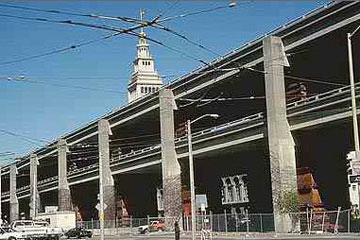
before: San Francisco's hideous Embarcadero Expressway before the
World Series Earthquake took it down in 1989
source: geoimages.berkeley.edu
That is not, however, the end of the bleeding. According to the New York Times, the average state property tax rate in the US is 1.38%. So $1.17 trillion in lost property value costs the states over $16 billion per year in lost property tax. This number, so far as I can determine, does not include state school taxes. Many counties and cities levy property taxes as well. And a quick tour of the streets around most Cheapways reveals enough boarded-up windows that it's clear that billions in sales tax revenues are being lost as well. There is no clear way to estimate these losses because so many taxing authorities are involved, but based on the $16 billion lost just on state property taxes, the total is obviously well into the dozens of billions per year.

after: the fabulous Embarcadero boulevard that replaced it has
created untold millions of dollars in property value and tax revenue
I normally try to draw a persuasive conclusion about the contents of a post, but the numbers above speak so loudly for themselves that there's not much else to say. Let's just say that the Cheapway Consequence is simply a burden too great to bear. The time has come to tear the Cheapways down and replace them with great urban boulevards that create value instead.
~Steve Mouzon
Note: This post is part of an extended BlogOff on Return on Investment (RoI) of municipal spending. These are the posts in the BlogOff so far… please join us!
2/20/12 - The Speed Burden, Steve Mouzon
1/27/12 - On the Street: The DNA of place and the ROI of movement, Hazel Borys
Another Note: This is part of an occasional series on the costs of sprawl I started in March 2011 with Costs of Sprawl - Part 1, and continued with The Speed Burden noted above. Lots more to come… hopefully more quickly next time.
The Speed Burden [Costs of Sprawl Series]
search the Original Green Blog

Left: Renaissance Florence, Italy - Right: Atlanta interchange (both at same scale)
The need for speed devours huge chunks of American cities and leaves the edges of the expressways worthless. Busy streets, for almost all of human history, created the greatest real estate value because they delivered customers and clients to the businesses operating there. This in turn cultivated the highest tax revenues in town, both from higher property taxes and from elevated sales taxes. But you can't set up shop on the side of an expressway. How can cities afford to spend so much to create thoroughfares with no adjoining property value?
Let's first look at the four basic problems with speed:
Curves
Increasing speed a little bit requires a big increase in the size of curves. At 20 miles per hour, any car can handle a curve with a 15 foot radius, so you'd think that tripling the speed would triple the radius, right? Wrong. At 60 miles per hour, curve radii are usually a few hundred feet, not the 45 feet you might guess.
Lane Width
Faster roads need wider lanes. An 8 foot lane can handle 20 mile per hour traffic, but at highway speeds, you need 12 foot lanes.
Medians & Shoulders
High-speed roads need wide medians and shoulders because a car can roll hundreds of feet beyond the point of collision or loss of control when it is traveling at highway speeds.
Number of Lanes
It makes no sense to use all that land on either side for a two-lane highway, so high-speed thoroughfares usually have at least four lanes, often several more.
Florence vs. Atlanta Interchange

Florence, Italy
Look at Florence above… the blocks are tiny, and the streets are never much more than hairlines. From this high up in the sky, the intersections look like sharp right angles. This is because Florence was laid out for people and horses, which can turn on a dime. Cars drive on these streets today, but they drive slowly, which is far safer for the pedestrians.
The Atlanta interstates are each as wide as 2-3 blocks of Florence. The entire Duomo (the cathedral in the center of Florence that arguably began the Renaissance) could fit in one of the inner loops of the interchange, as you can clearly see. The central core of Florence, from the Duomo to the river, would fit inside the inner box of the interchange. The world was irreversibly changed by the people living and working in Florence who gave birth to the Renaissance. The interchange will never change the world… at best, it gets a small fraction of Atlanta workers to their jobs a bit sooner, barring any accidents.

Atlanta interchange
Seaside vs. Miami - A Closer Look
Let's analyze this at a larger scale. Each of the following two images is a half-mile wide and contains 90 acres of land or sea. The first is DPZ's Seaside, Florida, which as you may know is the birthplace of the New Urbanism. Its fabric is not so different from the scale of neighborhoods we built everywhere in the US before World War II. The second image is an urban interchange along Interstate 95 just north of downtown Miami. I selected this location because the urbanism is relatively tight here, and the curves are minimal. I could have picked something further out in suburbia that was looser, but that would be like shooting fish in a barrel.

Seaside, Florida (same scale as I-95 in Miami)
Looking at these images, it's immediately clear that there's a lot more paving in the Miami image than in Seaside. But if you start counting blocks, you'll see that there are 27 blocks of urbanism in Seaside (even though 13 acres in the lower left corner is lost to beach and sea) while there are only 15 blocks in the Miami image, depending on what you consider a block. That gives us a pretty good hint that maybe there's more real estate value above than below.

I-95 in Miami, Florida (same scale as Seaside)
The Speed Burden - Land Area

green land: has real estate value ~ red land: no real estate value
One measure of land value is acreage. In Seaside, 80.5% of the available land has real estate value; only 19.5% of the land is taken up in thoroughfares. Note that I have included parks, greens, squares, and plazas as having real estate value even though they cannot be sold because studies have clearly shown that open these types of natural spaces create more real estate value in nearby lots than if they had been sold as private lots.
Only 62.6% of the land in the Miami example has any real estate value because the thoroughfares consume 37.4% of the land. Based on Seaside, it would be reasonable to say that about 20% of the land in a traditional neighborhood should be allocated to thoroughfares. The Miami example consumes almost twice as much: 37.4%/20%-1 = an 87% Acreage Speed Burden. How can we afford to burden the land with 87% more thoroughfare acreage than necessary for a vibrant walkable environment?

green land: has real estate value ~ red land: no real estate value
The Speed Burden - Frontages

green frontages: full value
Acreage isn't the only metric of land value. The "front foot," or length of the front property line is another metric of real estate value that is perhaps more useful than acreage. In Seaside, every single foot of frontage is full value, meaning that it either has addresses of private lots along it, or it opens into parks, greens, squares, and plazas. Even though only 77 of the 90 acres are buildable (the rest being beach and sea) Seaside has generated 36,200 feet of full-value frontage.
The Miami example doesn't fare nearly so well. The frontages along the I-95 and its exit ramps have no value at all. Even if you wanted to open up a shop there, it's illegal to do so. There are 9,531 feet (almost two miles) of worthless frontages here. Some of the frontages are shown as "partial value." These are frontages that are either 100% side streets (no front doors) or frontages that have been ruined with big parking lots just behind the sidewalk. There are 6,303 feet of partial-value frontages in this image. That leaves 17,820 feet of full-value frontage, for a total of 33,654 feet of frontage of all types. Interestingly, Seaside generated a half-mile more frontage on 13 less buildable acres, and all of it is full-value, whereas only 52.9% of the Miami frontage is full-value. So even if Seaside had built as much on the full 90 acres instead of the 77 buildable acres, that would still be a 47.1% Speed Burden based on full-value frontages.

green frontages: full value ~ olive frontages: partial value ~ red frontages: worthless
How can we afford to pay so much and get so little? Cities really do need to rethink their infrastructure priorities. We are beyond the point where we can spend enormous sums of money with little or no return. Municipalities, from cities to towns, villages, and hamlets, all need to take a careful look in the mirror each time they want to spend money and ask themselves: "What is the return on this investment?"
~Steve Mouzon
Note: This post is part of an extended BlogOff on Return on Investment (RoI) of municipal spending. Hazel Borys started the BlogOff with the following post… please join us!
1/27/12 - On the Street: The DNA of place and the ROI of movement, Hazel Borys
Another Note: This is part of an occasional series on the costs of sprawl I started in March 2011 with Costs of Sprawl - Part 1. Lots more to come… hopefully more quickly next time.
Why Love Matters
search the Original Green Blog

Wanda, with Buddy, in the side garden at the Dixon
Lovability, a concept deeply distrusted by architects of most stripes, is actually the gateway to sustainable architecture because if a building can't be loved, it will not last. And lovability is a better standard than beauty, as we shall see.
Why should love be the first threshold on the path to sustainable buildings? And why is lovability so important that it's also a major component of sustainable places? Many of my colleagues who are classicists have long insisted on beauty as the highest standard, whereas many of my colleagues who are Modernists have long disputed that stand, preferring grittier or more industrial aesthetics while claiming that beauty is in the eye of the beholder. We'll never get agreement between these two groups on beauty. Both of these groups recoil, however, at a term so unprofessional as "lovable." "That's barely a step above 'cute,' or even worse, 'precious,'" they might say. But ask any non-architect, and they have no problem at all talking about lovable buildings and places, and they'd really like it if we were to design more of them.

But the fact that architects can't agree on beauty isn't the most important reason why love is a higher standard. Let's think about beauty for a minute. Like this nameless stranger on a balcony in Cuba, beauty can be warm and engaging. (She smiled, I snapped the picture, and she gave me a thumbs-up, so I'm assuming it's OK to use the image, although I have no idea who she was.) But that's only one side of beauty.

As countless melancholy works of song, pen, and brush have attested for centuries, from tragic ballads of centuries past to today's sad country songs, beauty can also at times be hard, or maybe cold, and can definitely move us to unhappy states of mind. At times, beauty and our inability to attain it or to hold onto it, has moved people to all sorts of unfortunate and regrettable choices. So beauty, while powerful, can also be fickle, and often fades with time.

But at its best, beauty moves us to admiration, and admiration can be a good thing. Love, on the other hand, moves us to action. This is my dog Sally, and because I love her, she gets to do all sorts of things that I wouldn't tolerate of an unloved creature.
One more illustration: Look at Wanda's picture at the top of this post, then scroll down and look at my picture in the sidebar. What's not obvious just by appearances is that we've been together for nearly 33 years and have shared love about as equally as any two people ever do. What's exceptionally obvious from looking at the pictures, however, is that we do not share beauty equally. As a matter of fact, had physical attractiveness been a factor, I'd have never had a chance with her, as you can clearly see! But because love did for me what beauty could not do, we're still together after nearly a third of a century.
That's why love is so important to sustainable places and buildings. It motivates people to do things and to make choices they would not otherwise make. If people are to think different and to choose different, then what they need is love.
~Steve Mouzon
New Urbanism for All?
search the Original Green Blog

classic corner store in Key West
We New Urbanists have an important choice to make, because our current rhetoric don't square up with our metrics in some important ways. If you listen to our aspirations, we'll tell you that 2/3 of Americans prefer thriving neighborhoods that are compact, mixed-use, and walkable over sprawling suburban subdivisions, and we'll tell you that those people should all be able to live that way… once we build enough of those neighborhoods and repair enough sprawl. But our rules of thumb sometimes tell a different story.
Hazel Borys hosted a PlaceMaking@Work webinar in December with Bob Gibbs based on his new book, New Rules for Retail. The ensuing tweet chat is what started this whole Neighborhood Retail BlogOff. I haven't yet read Bob's book (it's on order) and I have high regard for him on many counts, but one of Bob's rules of thumb is that it requires 1,000 homes to support a single corner store, and more than that to support anything else. I responded by blogging that if that's so, then any neighborhood with less than 1,000 homes would have no hope of any mixed-use, and could therefore not ever be more than a residential subdivision.

one of several corner stores in Hazel's former neighborhood -
German Village, Columbus, Ohio
Hazel's well-reasoned reply began with a foundation of physics, leading up to a discussion of where rules can be broken in urbanism. The post is full of useful facts, but she dismisses my post because it used Seaside as an illustration, and a resort doesn't follow normal rules of thumb.
Fair enough… but the questions at the end of this post are about everyday neighborhoods instead of resorts, so I'm curious to hear her thoughts on them.

New Haven boutiques
Sandy Sorlien posted next, with a plea to "be quotidian." It's cool to have friends who are a lot smarter than me, but it does make for lots of dictionary searches. "Quotidian," it turns out, means "everyday, ordinary, or average." She goes on to explain that neighborhood retail should first of all stock regular everyday needs before even thinking about boutique products. I completely agree, and that's the point of this post as well: where do you have to go to get your basic necessities? And can you walk or bike to get there?

neighborhood market in New Town at St. Charles, Missouri
Patrick Kennedy followed with pointed questions about subsidies of neighborhood retail. Without doubt, a corner store needs subsidies in a neighborhood's early years, but those subsidies boost sales because prospective homebuyers typically consider a corner store to be a significant "amenity." I put "amenity" in quotes because it's real estate jargon for something that should really be considered a necessity. Kaid Benfield tells why: because when shops and services are within walking distance, we walk more and drive less.
John Olson makes an excellent point that retail should be adjacent to the neighborhood it serves, whereas some neighborhood diagrams show it centrally located, where it likely will fail. More on that in a later post. And then Chip Kaufman posted four additional rules of thumb for making neighborhood retail work.

neighborhoods without a lot of townhouses are very unlikely to
exceed 10 homes per acre
But let's get back to the central question: does the 1,000-home rule of thumb overturn our foundation principles? New Urbanists in the US have forever insisted on a quarter-mile radius as the limit of a neighborhood because that's about as far as US citizens will walk instead of driving. That radius encloses roughly 125 acres, but unless every street radiates from the center, the walks are longer, so the effective neighborhood size is closer to 100 acres. This means that unless the gross density is at least 1,000 homes / 100 acres = 10 homes/acre, you can't even have a corner store. I hate to break it to you, but only a tiny fraction of the American landscape contains more than 10 homes/acre.
There's another way to make it work. You could have a corner store that serves 2-3 neighborhoods, but then only 1/2 to 1/3 of the people could walk to the store because everyone else would be too far away… and that only works when the gross density is at least 3-1/2 to 5 homes per acre.
But this isn't New Urbanism for All. Instead, this is New Urbanism for the Few. Is that really what we stand for? Principles that add up to a niche market for the privileged few? I thought we were better than that… aren't we? If we're not satisfied with rules of thumb that prevent a mix of uses in every neighborhood (degrading the neighborhood to a residential subdivision) then how do we account for the experts' assertions that the retail will fail? What has to change in order for it to work? And not in some ideal future, but with the conditions on the ground today? More questions than answers… there is work to be done.
~Steve Mouzon
Note: This post is part of an extended Blogoff on the viability of neighborhood retail. The most recent posts from BlogOff participants are as follows:
1/31/12 - Chip Kaufman Guest Post - Neighborhood Retail, Chip Kaufman
1/29/12 - Neighborhood Retail Dynamics, John Olson
1/11/12 - When shops and services are within walking distance..., Kaid Benfield
1/5/12 - Retail BlogOff, Patrick Kennedy
12/28/11 - BlogOff: Neighborhood Retail, Sandy Sorlien
12/23/11 - Retail: When it bends the rules and breaks the law, Hazel Borys
12/21/11 - The Necessity of Hope, Steve Mouzon
